
 I love looking at aerial views and maps, searching for the roads and seeing where they lead. And ever since I was bitten by the mountain biking bug, I've been checking around for places that might offer some good off-road cycling.
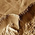
This aerial view came to me yesterday while I was looking at some new online maps. Looks like a cool canyon with access via dirt roads or stream beds. Kind of like the Grand Canyon. But it's completely pristine, no tourists or other bikes. That's because it's on Mars.
The view comes from the new Google Mars aerials released in collaboration with NASA researchers at Arizona State University. This shows an infrared view of the edge of Mariner Valley; a color-coded elevation view shows the elevation change here is about 3km, or 1.9 miles. What a monster climb!
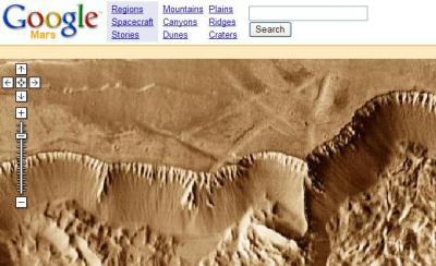 Google says the views were taken from spacecraft orbiting the Red Planet. Just like with Google Local, you can search for locations, or by highlighted articles, regions or rover landings. Eventually, Google says it plans to use the Google Earth client for the Mars maps, so viewers can easily zoom in and out and tilt to get a better feel for elevations.
For more realistic mountain biking pursuits, in other words bike paths on Earth, check out the Singletrackwiki sponsored by The Steeps. Cyclists can add their favorite trails to the map guide by locating in on a Google map, then explain some details about it, with pictures.
Recent Comments