
Tuesday, July 3, 1984
Isleta Indian Reservation to El Morro National Monument, NM
90 miles
Locator map
I’m reprinting the day-to-day journal entries of a cross-country bike tour my friend and I took in 1984. More about the TransAmerica Tour 1984
Bis’ Journal
We passed through several nations today; those of the Isleta, Laguna, Acoma, and Canoncita. They’re all pueblo tribes that thrived here before the Spanish Conquistadors and missionaries enslaved them. English is spoken here, but it’s not the native tongue.
None of that mattered to us this morning. We awoke out in the desert while there were still a couple of stars in the sky and the sun was brightening the East. We walked back to our bicycles hidden under the railroad trestle and Bruce removed that crudely carved horse’s head, given to him in Missouri, from his handlebar pack and set it on the trestle support. I imagine it will startle whoever finds it.
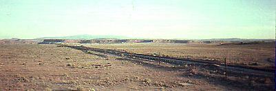
We followed the road about 5 miles to I-40. Nothing at the interchange and we had to ride on the Interstate shoulder a few more miles to Laguna, the first town with services. I’m glad we stayed where we did last night.
It was already hot and I was thirsty when we got to Laguna. We met Greg Lewis here, a silversmith who owned a shop. He said his father sold silverwork to tourists who stopped at the train depot, but the family moved to San Francisco during WWII for the shipbuilding industry. Greg says he decided to move back to the “motherland,” where he enjoys the “kick back” lifestyle. Kickback or not, he was hard at work making jewelry before other businesses in town opened, including the restaurant.
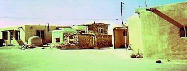
Greg told us about the Laguna pueblo, where Native Americans in the region came to try to escape the Spanish dominance ini 1699. They moved to the top of the mesa, where there are still buildings and a church. Greg said the folks here practice Christianity, with their ancestors’ religion mixed in.
I could have talked to him for hours, but we’d put ourselves on a schedule so we wouldn’t get stranded again. We rode along a frontage road and part of old Route 66 again to Grants, the town uranium built. This area was an earlier supplier of uranium, used to make nuclear weapons. We skipped the Radium Cafe and headed to a Pizza Hut.
It was crowded with lunch customers, but we couldn’t seem to flag down a waitress. No wonder. I was wearing the same T-shirt I’d put on yesterday morning in Albuquerque (same shorts and socks too), and that grainy film on my face was a mixture of trail dust and dried sweat. But we stayed for the salad buffet (often our only source of greens) and pizza.
The road climbed back into the mountains from Grants and passed through the Mal Pais lava beds, huge chunks of black rock scattered everywhere. We had 42 miles to cover to El Morro campground and I cycled in a trance, plodding along through a light rain and back into the sun. We were up in the Cibola National Forest and evergreens appeared on the roadside. Stopped at a place called the Ice Caves, which encompassed the rim of the extinct volcano we’d been climbing and had left the lava beds behind.
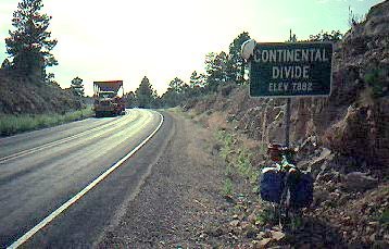
Crossed the Continental Divide again, this time heading back toward the Pacific. We arrived at the El Morro National Monument five hours after leaving Grants. We washed up in the men’s room and headed up to a campsite at north park. We had a clear view of El Morro, a massive sandstone mesa rising 200 feet from its surroundings. Called “inscription rock,” many travelers, like the Spanish, left their initials in it. The whole thing looks like a huge ship passing through the countryside.
We ate and watched the sun set behind the mesa. That night, our friends the coyotes serenaded us again.
Headline: July 3, 1984 —
The US Supreme Court lifts a ban
that prohibited editorials on radio and TV stations
funded by the Corporation for Public Broadcasting…
Bruce’s Journal
Up and on the road before 6. a.m. No camp to break and no breakfast to cook. We watched the sun rise as we made our way down the road. It felt like we had barely stopped from the night before.
I felt dirty in the morning–sticky and sweaty–and I feel twice that now, camped at El Morro National Monument, about 60 miles from Gallup. No shower again tonight. We have been riding for 12 hours each day, trying to make Gallup by the 4th of July so we can see the parade and go to the rodeo. As it looks now, we won’t get there until 3 or 4 in the afternoon.
We came through Grants this afternoon, and across another Continental Divide (about 7,200 feet above sea level) on our way to El Morro, which is a fantastic rock formation where Indians had live since the 800s. I am watching the towering formation now from our campsite as the sun sets and turns the sky orange. There is a quarter moon tonight and the sky is clear.
[According to the Britannica: “El Morro (the `Headlands’ or `Bluff’) or, Inscription Rock, is a soft sandstone mesa rising 200 feet above the valley floor and covering several acres. A water catchment basin and sheltered coves at its foot made it an important camping place … Indians, Spaniards and Americans left their inscriptions (1605-1774) on the cliff sides of the mesa. El Morro also has a number of pre-Columbian petroglyphs, and on its top lie ruins of Zuni Indian pueblos.]
Coming through Grants, we passed the Uranium Cafe. We’re not too far from Los Alamos.
Tomorrow:
Day 53 — Celebrating the Fourth in Navajo Nation
1 pings
[…] rest is here: Day 52 – Bicycling through reservation lands ← Bicycle Ride to Honor Hit-and-Run Victim; Spread Safety […]