
That landslide on Saturday that swept down a hillside along the North Fork of the Stillaquamish River also took out a section of the White Horse Trail, a mountain biking and hiking trail.

Aerial view of landslide area from WSDOT
Recent heavy March rains are considered responsible for the deadly landslide onto State Route 530 near the town of Oso. Three people are dead and at least eight are injured. News reports in the Everett Herald on Sunday reported 18 missing.
Along with Highway 530, a section of the White Horse Trail east of Oso also was swept away by the landslide.
The trail is a 27-mile-long corridor of the old Burlington-Northern Railroad connecting Arlington and Darrington. It roughly follows State Route 530 as it winds along the river through forests and farmland.
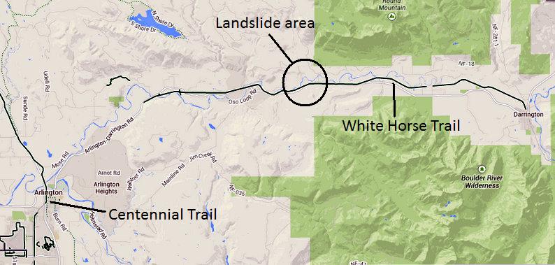
Area of landslide and White Horse Trail
Most of the trail is not officially open to use, however, because of dangerous trestles along the western part of the route. Between 6 miles and 10 miles of the trail are open to the public — a section between Swede Heaven and Darrington and another between Arlington and Cloverdale Farms. The stricken area is in between those two open areas.
Elsewhere, hikers and mountain bikers can access the trail at road intersections. One hiker, for instance, reports on Washington Trail Association website that he hiked between Whitman Road and Oso last year along a section of trail that’s not officially opened. That’s in the vicinity of Saturday’s landslide. He wrote about crossing the river on a trestle; the decking was comprised of railroad ties.
Many of those trestles are closed until permanent decking can be installed.
Another group reports on the Washington Trail Association website that they used an open part of the trail earlier this month . They noted that the riverside trail was beginning to wash away near Darrington.
The White Horse Trail joins the popular Centennial Trail in Arlington at the confluence of the North and South forks of the Stillaquamish River.
The Everett Herald reported that authorities closed Haller Park at the confluence because the North Fork had been blocked by the landslide. They didn’t know when the logjam upriver would break and send the pent up water and debis downstream toward Arlington.
Washington State Department of Transportation said they’ll have hours to close the downstream bridges — Interstate 5 and state routes 9 and 530 — if the debris dam breaks, the Seattle Times reports. (The bridge that carries the Centennial Trail across the Stillaquamish River is located just upstream from the State Route 9 bridge.)
Recent Comments