[Check out Cross-Country Bike Rides for bicycle tour options]
 The route of our 1984 cross-country bicycle tour is still pretty much imprinted on my brain.
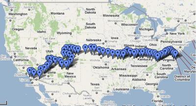
So when Google announced it had created bike directions for Google maps, I was interested to see how its suggested route compared with the route we took 25-some years ago.
The result is at right. It's quite different than our actual route, below.
Google's route from Yorktown, Virginia, to Oceanside, California, is shorter than our meandering route. It bypasses some steep climbs and makes use of rail-to-trails that probably still carried freight trains when we traveled that way on our bikes.
Our original trip, at left, followed Bikecentennial's (now Adventure Cycling Association) TransAmerica route from Yorktown, Virginia, into Colorado. We veered off onto their Great Parks South Bicycle Route from Salida to Albuquerque, then picked up the Southwest America Bicycle Route (created by Southwest Trails Association) all the way to San Diego.
At 3,989 miles, we knew it wasn't the shortest route cross-country, but it took in the Appalachians and Rocky Mountains, Great Plains and Southwest deserts. We experienced many cultural and geological wonders that we wouldn't otherwise have seen.
I cannot remember one mile of the trip that we didn't share with cars or trucks.
Google maps
So when I went to Google maps and asked for Yorktown to San Diego directions by bicycle, I was surprised by the results. First off, it supplied a route that was 3,192 miles.
The Google route reflects three factors that its search engine seeks when creating a bike route: bike trails, low or modest elevation change, and low traffic roads.
In places this creates very interesting options for a cross-country bicycle tour, such as where it heads due north out of Yorktown to pick up the C&O Canal Towpath in Washington DC. Elsewhere, like in the sparsely populated regions of the southwest, it appears to head across jeep tracks through the desert.
Check locally
Needless to say, you'll want to “check local conditions” before using the Google maps for bicycle touring. While it has some good information for many cities, the data for sparcely populated regions is scant, at best.
Between the two coasts, there are few places where our trail intersects with the Google route. One is El Dorado, Kansas. Others are Albuquerque and Gallup, New Mexico, a lonely intersection in the desert between Quartsite and Yuma, Arizona, and someplace in the Anza Borrego Desert Wilderness in California.
Rails to trails
The Google route appears to search out trails supplied by the Rail-to-Trails Conservancy as a priority.
After departing the C&O Towpath in Cumberland, Maryland, it picks up parts of the Great Allegheny Passage in Pennsylvania, then follows highways and gravel roads into West Virginia for the Monongahela River Rail Trail System and the North Bend Rail Trail.
In Ohio, it picks up the Tri-Couny Triangle Trail roughly between Chillicothe and Washington Court House, as well as the Jamestown Connector Bikeway and Prarie Grass Trail and Mad River Recreation Trail in Dayton. Still in Ohio, the Wolf Creek Recration Trail.
In Illinois, the Glen Carbon Heritage Bike Trail heads toward St. Louis, then the route picks up the Madison County Transit Schoolhouse Trail.
The route picks up the Katy Trail just west of St. Louis clear to Clinton, some 200 miles of flat riding through Missouri, home of the Ozarks. In eastern Kansas there's a short stretch on the Prairie Spirit Rail Trail, and that's essentially it for bike trails.
From there it's mainly back roads through western Kansas, Colorado and into New Mexico, where it picks up some bike lanes through Albuquerque, New Mexico, and Flagstaff, Arizona. Once it gets into California, the route picks up some bike lanes near Escondido.
Not built for bike touring
That's an amazing amount of traveling via bicycle trails from Virginia through Kansas. After that, the Google route — with the exception of hitting a few big cities — is mostly on very faint tracks through the scantly populated areas.
As good as this Google tool might be for local bicycling, it certainly isn't ready for cross-country touring or for traveling long distances by bicycle. That isn't its purpose. But at the very least, it certainly shows a wealth of opportunities for off-road bicycling and shows some options for travelers.

 Original route
1 comments
What is the best route from Springfield Missouri to Yuma Arizona?